Thursday, May 2, 2013

Wind, Weather, and You (Part 3)

We are on a Spinning Planet, Tilted on its Axis, Orbiting the Sun

 As we orbit the sun, different parts of the earth are warmed more intensely or cooled more than others. We grow a year older, and the cycle continues over and over again for 4 billion years. It is this basic concept that builds the earth as we know it. It creates forests, ocean currents, frozen tundras, summer thaws, and billions of species filling billions of niches. For us as humans it creates our food and spawns our disasters. There is nothing more primordial to us than weather. We owe all life and death to it. All because we live on a spinning planet, tilted on its axis, orbiting the sun.

In these next chapters we'll learn how these three factors of our planet (titled axis, spinning, orbiting the sun) create the world as we know it.

First a note:
This is where we hit the culmination of everything we've learned in the previous sections. Concepts in these chapters are more complicated, and I urge you if you've never had any background in Meterology to first read Part 1 and Part 2

Global Circulation and You

The earth is in a constant battle to equalize itself. We learned earlier heating in one place and cooling in another creates pressure gradients that try to equalize themselves.
Q: But why is it like this in the first place?
A: We live on a sphere.

The Hadley Cell

Lets assume a couple things for this section:

1. There is only water on Earth
2. We're in the northern hemisphere
3. The sun shines parallel to the equator (like it does on the equinox)
4. The sun does not move
5. The Earth does not rotate
6. The Earth is a relatively small system

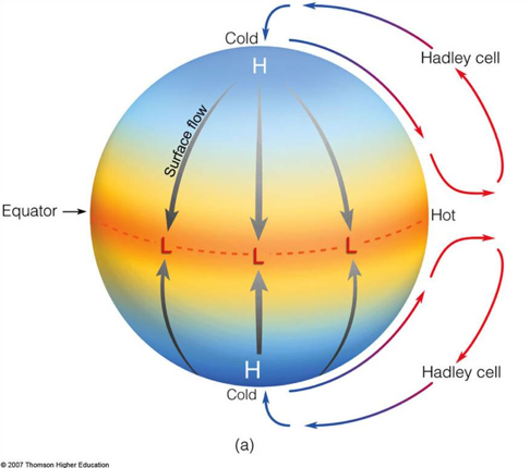
The sun shines at the equator. This rising air creates a low at the surface and high aloft. As air escapes upwards it hits the upper part of the atmosphere spreading outwards towards the poles. The air aloft cools as it moves northward leading to a sinking motion that creates a low aloft and a high at the surface. This high pressure at the poles then moves back towards the low created at the equator. Called a Hadley Cell this simplistic model tries to explain global circulation. In this model instability is created at the equator, while stability is created at the poles. We'd expect high amount of thunderstorms at the equator and clear skies at the poles, as well as strong northern winds at the surface.

But wait a second. This doesn't explain anything. Winds are much more complicated than this, it doesn't match reality. Why not?

The Three Cell System

Lets take out the assumption the earths not rotating and that its a relatively small system. Leaving us with the assumptions:
1. There is only water on Earth
2. We're in the northern hemisphere
3. The sun shines parallel to the equator
4. The sun does not move

What happens now?

Air at the equator rises creating a low at the surface and a high aloft. This time as the air moves towards the poles it is deflected to the right by the Coriolis effect. Air traveling northwards in the upper parts of the atmosphere travel south westerly creating SW winds aloft. Bringing in to account a large Earth, the air moving north cools and begins to sink around 30* latitude. The high created is called the Sub-tropical High. This creates a stable atmosphere with clear skies. The wind moving back towards the poles is deflected to the right again, and returns coming from the north east. We call these the North-East trade winds. It moves back towards the equator to an area called the Inter-tropical Convergence Zone. Basically a zone where winds on the ground are converging as the meet at the equator.

Some of the wind at the surface of the sub-tropical region moves northwards instead of south. Deflected to the right it moves in a south western direction, creating another set of trade winds we know as the Westerlies.

Now lets start at the poles. Sinking air at the poles create a polar low aloft and high pressure at the surface moves the only direction it can, southward. Deflected again it moves from the north east. This cold air hits the incoming westerly wind from the sub-tropical high. The lighter warm sub-tropical air and heavy cold polar air do not mix easily creating what we call the Polar Front. This stationary front creates rising air with vast instability, completing the 3 cycles.

The other trade wind features created by this system are the Doldrums and the Horse Latitudes

The doldrums are the area right at the equator where very little wind is encountered. Most air at this latitude is moving upwards not laterally, as it rises from the heat and the pressure gradient. This feature is famous in sailing and literature as an dangerous area where ships can get stuck for long periods of time.

The Horse latitudes are the area below the sub-tropical high where quite opposite from the doldrums sinking air diverges from high creating only light winds.

Well what does all this tell us?

Too much infact that we'll have to break it down in the next section

This global circulation model predicts fairly accurately: wind patterns, areas of high instability, location of rain forests, and deserts. As we've talked in depth about winds let's move on to storms.

Storms

From here we'll take out more assumptions. That the sun is parallel to the equator and the sun does not move. Which leaves us with:
1. There is only water on Earth
2. We're in the northern hemisphere

The three cell system predicts instability (and thus storm formation) at two places. First at the Inter-tropical Convergence Zone (ITCZ) where heat from the sun and incoming area create rising air that feeds storm formation. Second at the Polar front. The warm sub-tropical air converges with the dense cold air. The tendency along this boundary is for the warm air to rocket upward and cool, priming the atmosphere for storm formation.

We have to remember though that we're now on a planet that rotates around the sun, and with it the suns zenith moves northwards as summer sets in and southwards again as winter starts. This movement moves the cells and boundaries with them. In summer the ITCZ moves towards the tropic of Cancer (23* North of the equator) while the polar front is pushed far into northern Canada. During the winter the ITCZ moves south of the equator towards the Tropic of Capricorn (23* south of the equator) and the polar front moves towards the northern and central parts of the US.

This movement of the polar front is particularly important for the United States and the South where the Horse Latitudes suppressing storms and wind move south and allow the polar front to move in. This brings much needed storms to the south as well as aids in bringing cold fronts to cool off the country. (The Jet Stream aids in this as well, we'll deal with it another time)

This movement throughout the year creates high rainfall totals between both tropics and highest at the equator.

Forests

With rain comes forests. As you compare the two pictures (rainfall totals and forest locations) you can clearly see the majority of the tropical forests are created by the ITCZ. But what is up with the eastern united states and western Europe? Chile? The Pacific Northwest? Asia? The Rockies?

We'll finally take away all of our assumptions and look at the Earth closer to what it really is. A spinning earth, tilted on its axis, rotating around the sun with land and water mixed in.

The boreal forests as well as South East Asia and North America can both be explain with wind patterns. Sitting above 30* latitude they receive ample southwestern wind from the oceans, creating lots of moisture for rain and forests. The boreal strips from Europe, Russia, and Canada are from the largely unstable zone between the Polar and Sub-Tropical zones. This unstable front creates lots of snow during the winter and ample rainy seasons. These are amplified by the jet streams created along the Polar Front.

The Rockies and southern Chile can be largely explained by the addition of mountains and physical geographys effect on weather.

The Valdivian rainforest in Chile
Lifting of any kind can result in precipitation, if a column of air is physically forced upward it meets cooler air. As it cools the moisture is squeezed out of the air. Wind pushing air towards large mountain ranges, act as ramps for the air column, forcing air upward and an accelerated rate, forcing most of the water out of the air as it ascends. The higher the mountain the more intense the effect. The Rocky Mountains (~15,000ft) are overall twice as tall as the older Appalachian mountains in the eastern united states. The Chilean Coastal Range in South America are even larger (highest peaks ~20,000ft). This added to the emergence near the southern polar and prevailing wind directions leads to intense rainfall (up to 160inches of rain) creating the Valdivian Rain Forests. In North America, these conditions create the Quinault rainforest in Washington.

Deserts


To understand deserts in relation to latitude and the 3 cells lets look at them together:
 From here you can see quite easily that most deserts are right on the tropic lines. The wind's push moisture away from these locations not towards it. This problem is exacerbated when over large areas of land. The middle east suffers further by receiving wind from currently dry locations, creating a desert stretching far into Asia. 

Without any new shot of moisture from the ocean humidity plummets. This creates the opposite effect of living near the ocean. Without waters buffering properties in the air, things heat up and cool off quickly creating very hot days and cool nights. Conversely sweating is much more efficient in a dry location allowing better cooling than humid areas. This is largely why a dry 120 feels the same as a humid 100. Both are dangerous but for different reasons. The dry heat will take water from you quickly leading to dehydration. The humidity never allows your body to cool down leading to heat exhaustion.

Joshua tree in the Mojave (CA)
Ironically many of these deserts are further hurt by their relation to extremely tall mountain ranges and their consequent wet areas. These include the American south west (particularly the Mojave) and the Atacama desert in Chile. Any wind that comes from the ocean side is squeezed of water from the extremely tall mountain ranges, leaving almost no moisture left in the atmosphere for the regions leeward (the side facing away from the wind) of the mountains.


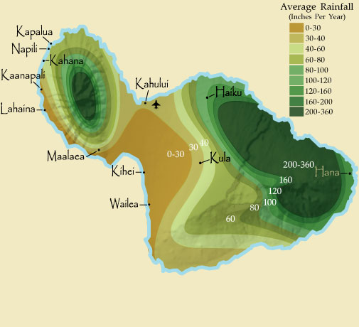
The effect elevation has on rainfall is best exemplified on the island of Maui which houses one of the highest rainfall extremes (300in+ above Hana to 12.5in in Kihei). The windward side of the island is the N/NE. As very moist air comes into the island it rises 10,000 ft dropping intense amounts of rain on the windward side of the mountain. By the time the wind wraps around the mountain the moisture is gone. So you can go from a rainforest to a desert in 20 miles. The wind does come locally directly off the ocean in the south, but its met by sinking dry air, leading to a pleasant tropical vacation at the beach that never gets ruined by rain. Which is why all the resort towns are on the south side of the island (Lahaina, Kihei, Wailea).
The Hawai'ian island Maui


Sunday, March 3, 2013

Wind, Weather, and You (Part 2)

Under Pressure

Pressure and wind are one in the same. Without a difference in pressure there would be no wind. Water is a special molecule. It's many special properties help build the oceans, feeds the rainforest, and makes up part of every organism on earth. Today we will look at how both these forces work to define the weather around you.

So what are high and low pressure systems?

High Pressure is a larger collection of air molecules in a single air mass compared to surrounding air masses
Low Pressure is a smaller collection of air molecules in a single air mass compared to surrounding air masses


Say we are standing on the equator, right below the sun at its zenith (the place it shines directly 90* down to earth). The suns rays travel through space warming up any matter it hits. Fortunately for most of space it has a nominal amount of matter. When it finally hits something like earth it heats up the mass that then radiates heat away from it into the atmosphere. Furthermore, as you increase in altitude towards space relative pressure decreases as the molecules spread out. This results in a gradient from 90* F at the equator, to -30* F at 30,000 ft, and -454* F in dead space.

That single ray of sunshine heats up your spot on the equator, heating up the air mass at the surface. We know heat rises away from the surface, as it rises it comes in contact with cooler air. This cools off the air mass as it rises and final hits a temperature equilibrium. This new colder air aloft naturally wants to sink back to the surface. The space at the surface has lost air molecules as they rose, while the air aloft has gained air molecules from the new cooled air. There are less molecules at the surface resulting in lower pressure, and more molecules aloft resulting in high pressure.


Air wants to move from high pressure to low pressure
 
So in our singular example at the equator, air will move upwards from heating, then back down to replace the lower pressure created at the surface. This cyclical system is known as a convection current. The same physics used in cooking in your oven are used to cook you on the beach.

The opposite of this effect happens at the poles where there is no heating from the sun. This cold air naturally wants to sink and collects at the surface, creating a high pressure system on the ground and a weak low above it.

Generally all high or low pressure systems are paired with the opposite system aloft.

The uneven heating properties of water and land

Water has a higher specific heat than land

Specific heat is the amount of energy a mass must absorb before rising 1* C. This means certain materials heat up faster than others (this is relative to molecular structure, composition, etc). Metal has a low specific heat requiring very little energy to heat up, compared to better insulators like water which heat up and cool off slowly. So water will take a longer time to heat up, while land will heat up and cool off much faster.

What this also means is a humid pocket of air will react differently than a dry one. The water in the air column will absorb more of the energy resulting in a slower heating of the air mass, and in reverse it will take longer to cool off.

Hot air holds more water molecules than cold air

The result of heating a substance increases its energy and movement of its atoms. This increase in movement creates larger space between each atom. Colder air has less energy and moves less, causing less space between atoms. In the same volume of air, water can occupy more space in the hot air than in the colder. This is why we refer to relative humidity so often in weather.

Relative Humidity- The percentage of water actually in the air compared to how much water it could hold.

Once humidity reaches 100% the water has to condensate out causing either rain, clouds, or fog (clouds at the surface).


That's great, but what can all this explain?
We can in fact predict many weather patterns and phenomenon with these.
 
1. Why it's windy near the ocean and why they shift direction at night. As the sun heats up the land and the ocean, the land heats up much quicker creating a low at the surface, while the cooler ocean creates a high at the surface(remember each one has its own corresponding H or L pressure aloft). The air escaping upwards on land is replaced by air from the ocean creating offshore winds.

At night the opposite occurs, the land cools faster than the ocean creating a H at the surface and the still (relatively) hot ocean creates a L at the surface. The wind moves from H to L and shifts the wind direction 180 onshore.

Let's add the second half of that pretty picture now

2. Why the southern hemisphere is relatively cooler than the northern hemisphere. The southern hemisphere contains less land mass than the southern hemisphere. The ocean is much harder to heat up and stays cooler, the result is a cooler overall climate as there's less land to heat up the atmosphere.

Using the equator as a guide and ignoring Antartica, most of the land on Earth is focused in the northern hemisphere.

3. Why it snows in Hawai'i. In dry conditions you can expect the thermocline (temperature gradient) in the atmosphere to decrease 5.4* F for ever 1000ft altitude and 3.3*/1000ft in high humidity and rain. So an island that is 80*F at the ocean (0 ft altitude) can expect to be 74.6*F at 1000ft, 69.2*F at 2000ft, and somewhere between 5.48*F  or 34.46*F at the summit of Hawaii's tallest volcano Mauna Kea (13,800ft). Now these numbers are not perfect, for one it's never been less than 12*F at Mauna Kea. This is due to the many complications arising from its proximity to the ocean, wind, humidity, relative climate, etc. But on a smaller scale you can guess the temperature of any mountain top from where you're standing. This same effect keeps permanent snow caps (glaciers) on the tallest mountains in the nation and world.
The big island of Hawai'i

4. Why its harder to get below freezing at the beach and harder to get above 100*F. Large bodies of water like the ocean take a lot of energy to heat up and cool down and are thus always lag behind the land in temperature. This means that the air at the ocean surface is going to be warmer than the land when its cold and colder than the land when its hot. High humidity in the air acts the same way and takes longer to heat up and cool off. So land right on the coast takes more energy to heat up and is regularly cooled by the relatively cooler offshore wind. This is why Snowbirds migrate to the southern coast in winter! The difference in temperature from the coast to inland can be as extreme as 20 degrees. (I wish I had a good picture of this from the 1st of February when it was 70* where I am in coastal Mississippi and 50* in central Mississippi.

5. Much, much, more, which will be covered in Part 3

Sunday, February 24, 2013

Wind, Weather, and You (Part 1)

The Science of Meterology

Today I want to talk about global wind patterns and weather and how this effects ecosystems throughout the world! I know, winds sound boring. But they're huge global systems that drive the ecosystems and create all the terrestrial niches for the floral and fauna of the world. Hopefully by the end of this you'll understand why every desert and forest is where it is and appreciate that tiny breeze on your face.

What you perhaps don't know is that wind that's blowing right now is part of a process starting thousands of miles away from you. You're experiencing a fight between the frozen poles and the toasty tropics beneath the suns zenith.


First things first. A quick brushing up on some physics that paramount to meteorology (The study of weather and climate)

Convection currents and moisture

Hot air rises and cold air sinks. You experience this daily whether its cleaning out your attic on a hot day, or trying to heat the bottom floor of your cold loft apartment. A packet of hot air generally rises in the atmosphere until it cools off or is obstructed and moves laterally.

Hot air holds more water than cold air. Tighter packed molecules of cold air can't hold enough water between each molecule compared to the fast moving molecules in hot air

If a hot packet of air is released it will rise in the atmosphere until cooling off. The cooler air losses its ability to hold as much moisture in the air condensating any excess water packed between the molecules out of the air. In most cases this creates clouds. If the lift upward is fast enough or there's enough water in the air, rain is formed.

A more complicated physics explanation

The Coriolis Effect

Imagine you are on a carousel going clockwise and you roll a ball from the carousel to your friend whose sitting across from you. Everytime you roll the ball it never rolls straight to him. Instead it rolls to his left. If you were going counter clockwise it would roll right. Now imagine you're trying to do this but on an entire spinning planet. A person standing on the northern hemisphere would always have things shift to his right when moving north to south. And always to his left when moving south to north. You won't experience this effect as a small speck on a giant rotating sphere, but you can observe it on much larger objects like pressure systems, wind, and hurricanes.

As the middle of the carousel is spinning faster than the farthest edges the balls degree shift increases as it goes towards the middle and decreases on the edges. This is why the Coriolis Effect is essentially zero at the equator. That in very simple terms is the Coriolis Effect. It is not a force like gravity but an effect of living on a rotating planet.

You can see this beautifully in this image of 150 years of tropical storms and hurricanes from NOAA.
The effect only shifts the path slightly till 30*, at which point it takes over more and more until many storms are 180* from their original 'trajectory'

What does it tell us?
This tells us that large systems will 'appear' to shift to the right in the northern hemisphere and shift to the left in the southern hemisphere.
What does it not tell us?
Why toilets flow in a particular direction. The Coriolis Effect is not a force and only appears on systems large enough to perceive it, not your tiny toilet. Most toilets flush in a particular direction depending on the manufacture and hydrodynamics. Anything you've ever heard about this is bogus and shows a lack of understanding about what is the Coriolis Effect.